Introduction
100% Eastfield Resources subject to an underlying royalty to the original vendor
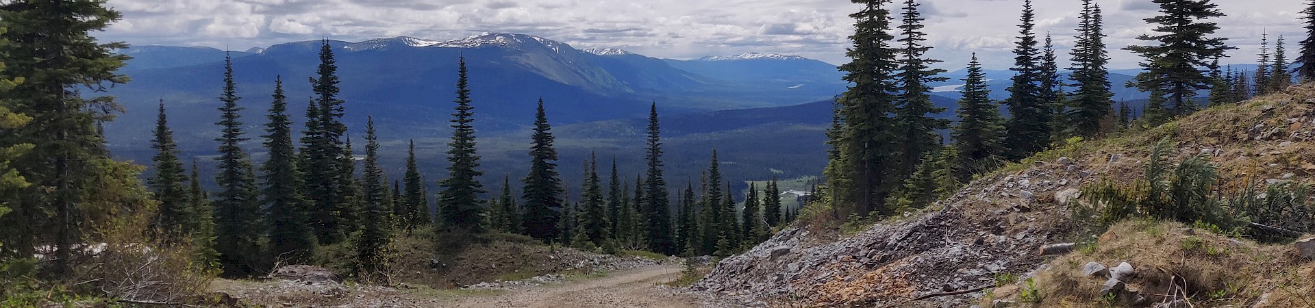
Zymo is a 12,113 hectare property that lies approximately 40 kilometres west of the town of Smithers, in northwestern British Columbia. The geology and mineralization styles at the Zymo property indicate copper-gold porphyry and porphyry related high sulphidation gold-silver-zinc stockwork and vein occurrences.
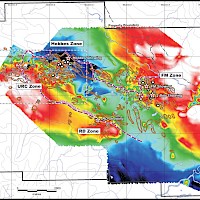
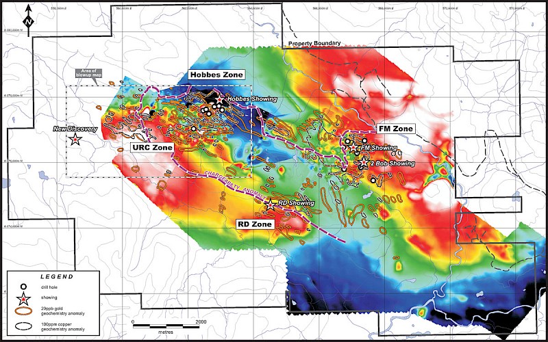
The Zymo property hosts at least two large copper-gold porphyry, intrusion-related, mineralized zones known as the Hobbes zone and the FM zone. Other areas of interest are the untested RD zone and URC zone which have an unexplained gold soil anomalies with coincident geophysical anomalies (magnetic high and IP high).There still remains potential for adding new targets.
History
The first noted discovery of mineralization in the Zymo Ridge area was by Corona Corporation in 1987 while following up a government regional geochemical survey gold anomaly on Red Canyon Creek. They noted anomalous gold values in a quartz-sericite-pyrite altered intrusion. Small programs in 1990-1 and 1996-7-8 were largely geochemical sampling programs including stream sediment, rock sampling, and the emplacement of a soil grid.
In 1999 Freeport Copper Company (Freeport-McMoRan) optioned the property. Freeport drilled six core holes in the FM Zone, confirming the presence of a potentially large porphyry system and the drilling suggested they were in the flanking zone of phyllic alteration.
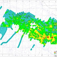
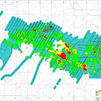
An 823 line-kilometre airborne geophysical survey was completed in December 2004 by NDT Ventures Ltd.
Eastfield optioned the Zymo property in mid 2007 and carried out a reconnaissance exploration programme from September 20 to October 10, 2007. The programme was designed to look at known areas of mineralization to understand the geology, mineralization and alteration of the area of the previous work, and to assess the economic potential of the rest of the property. The Hobbes Zone was discovered at this time.
In 2008 and 2009 exploration was funded by NGEx Resources Inc., formerly Canadian Gold Hunter Corp., a Lundin controlled company, and in 2011 and 2012 exploration was funded by Bearing Resources Ltd and completed the earn in with the original vendors.
Geology
The Zymo property is located along the Skeena Arch within the Stikine Terrane at the southern edge of the Bowser Basin. This area is largely underlain by clastic sedimentary rocks of the Skeena (early Cretaceous), Bowser (middle-late Jurassic) and Hazelton (early Jurassic) Groups, with Hazelton volcanic rocks mapped to the southeast of the claims. These rocks have been intruded by granite and diorite of the Eocene Nanika and late Cretaceous Bulkley Intrusive suites.
Strong west-northwest to northwesterly trends are reflected in several elements and may describe regional structures. Red Canyon and Mulwain Creeks display parallel northwesterly trends which are also very evident in the airborne magnetic survey in their vicinity. Linear resistivity features can be seen to display northwesterly trends that often parallel or coincide with magnetic features. The contact of the Bowser and Hazelton Groups forms a west-northwesterly linear in the extreme southern part of the property.
The property is composed of various formations of fine to coarse clastic sediments which host numerous intrusions of dioritic rocks. The intrusions are often porphyritic and range from dykes to bodies over one square kilometre. Local exposures of intermediate volcanics have been noted within the sedimentary package.
The alteration pattern around the mineralization runs from widespread iron carbonate alteration in the sediments around the various intrusions with strong sericite-pyrite alteration occurring in the intrusive rocks and in the surrounding sediments. The zones of mineralization are strongly altered with silicification, both as flooding and veins, k-feldspar, chlorite and magnetite alteration. The sediments in the Hobbes area have been strongly hornfelsed with biotite and chlorite.
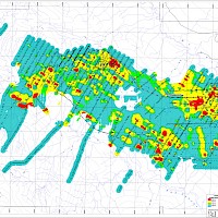
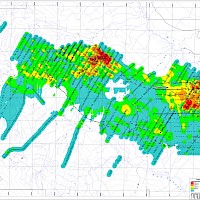
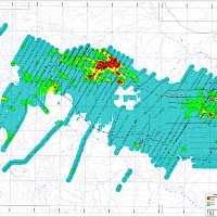
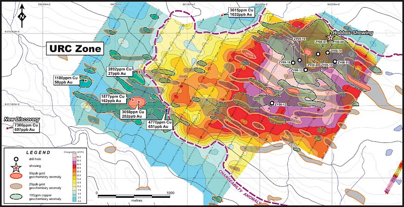
Geophysical work in 2008 and 2010 revealed an extensive chargeability anomaly that is approximately 8.0 km long and up to 2.0 km wide. The two known areas of mineralization occur on the north edge of this anomaly, while the URC and RD zones are on the south edge.
Mineralization
The Zymo property is host to four known occurrences of calc-alkaline copper-gold porphyry mineralization.
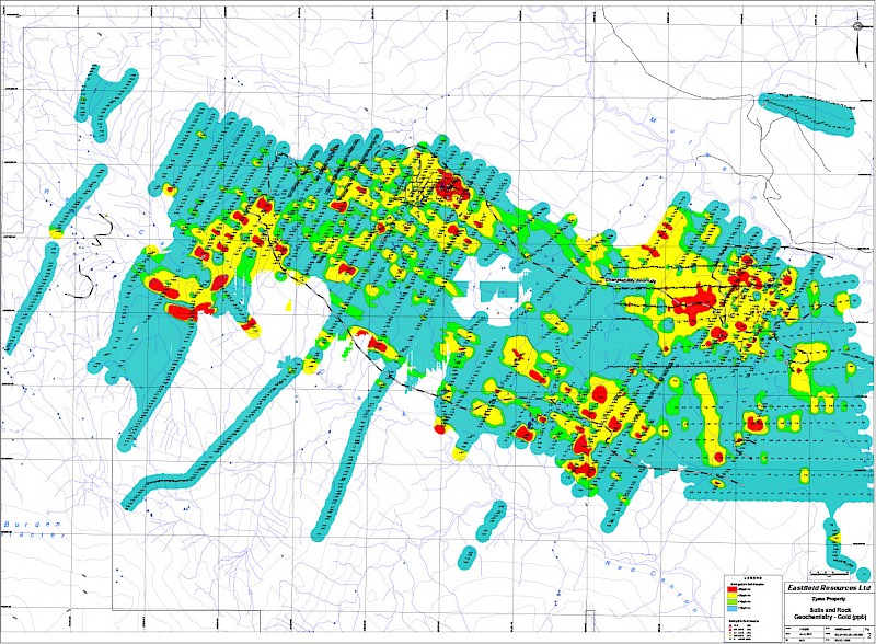
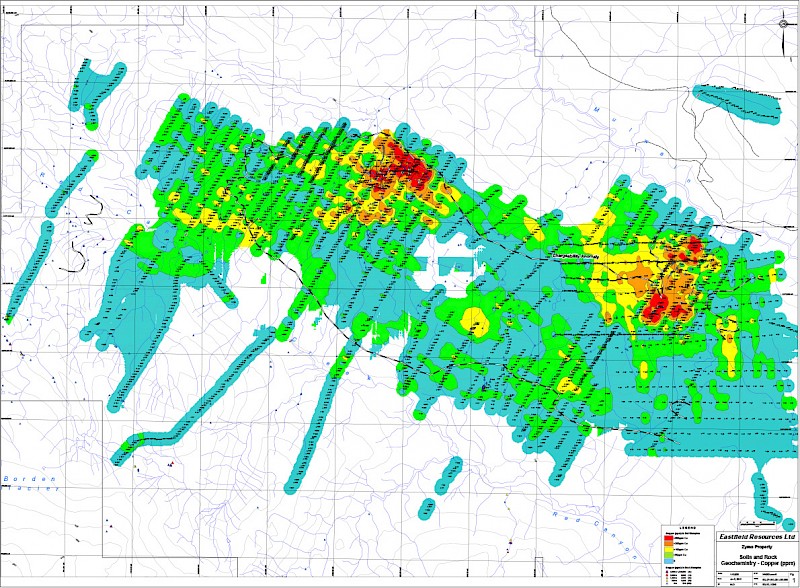
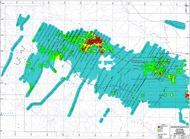
The Hobbes Zone is an 800 m long open-ended zone of disseminated and stockwork quartz-chalcopyrite in strongly silica-magnetite flooded diorite porphyry and the adjacent sediments. It was discovered in 2007. Drilling in this zone returned intercepts as high as 0.72% Cu and 0.54g/t Au over 72.0 m in hole ZY-08-09. The mineralized zone is surrounded by large halo of strong sericite-pyrite alteration and hornfels in sediments and dykes. This zone is associated with a strong magnetic-resistivity high in the north side of the main chargeability anomaly, and also has a strong Cu-Au-Mo geochemical signature.
The FM Zone is located 4.5 km northeast of Hobbes, and is composed of a 1.0 km x 1.5 km sericite-pyrite altered intrusion. Chalcopyrite and local bornite occur in number of structurally controlled silicified zones within this. Freeport-McMoran drilled six holes here in 1999 and encountered long intercepts of anomalous copper-gold mineralization, though none of these holes were close to any of the known surface showings. This area has a marked Cu-Au geochemical signature.
Auriferous base metal sulfide veins occur in a number of locations on eastern part of the property. These veins are as large as 1.0 m wide and 100 m long and have returned values of over 17g/t Au and over 300g/t Ag. The veins have been noted occurring proximal to the FM Zone intrusive, and also in another area to the southwest known as the RD Zone which is outlined by a 1 km diameter Cu,Zn-Pb-As-Sb anomaly. Two short drills were completed in the zone and returned two intercepts of quartz-sulphide stockwork in an intensely argillic alteration zone. These intercepts were each 3 m long and returned 0.22 g/t Au/0.19% Cu/47.9 g/t Ag and 0.99 g/t Au/0.91% Cu/72.8 g/t Ag. This area is interpreted to describe a typical alteration zone lying above a Cu-Au porphyry system such as seen at the Hobbes Zone.
Work in 2008
After an extensive IP survey over the Hobbes and FM Zones, a total of 1,554.5 metres was drilled in six holes on the Hobbes Zone. All of the holes intersected significant intervals of copper/gold mineralization with the best interval being 72.0 metres grading 0.72% copper and 0.54g/t gold starting at 15.0 metres in hole ZY-08-09. A summary of the drill results is as follows:
| Hole ID | From (m) | To (m) | Core Length (m) | Cu % | Au g/t |
|---|---|---|---|---|---|
| ZY-08-7 | 3.05 | 252.98 eoh | 249.93 | 0.20 | 0.14 |
|
including |
116.0 | 182.0 | 66.00 | 0.33 | 0.20 |
| ZY-08-8 | 3.05 | 237.74 eoh | 234.69 | 0.20 | 0.12 |
|
including |
51.00 | 111.0 | 60.0 | 0.39 | 0.26 |
| ZY-08-9 | 3.05 | 256.02 | 252.97 | 0.32 | 0.23 |
|
including |
3.05 | 162.0 | 158.95 | 0.44 | 0.32 |
|
including |
15.0 | 87.0 | 72.0 | 0.72 | 0.54 |
| ZY-08-10 | 3.05 | 162.00 | 158.95 | 0.31 | 0.21 |
|
including |
18.00 | 75.00 | 57.00 | 0.43 | 0.32 |
| ZY-08-11 | 6.10 | 153.00 | 146.90 | 0.16 | 0.10 |
| ZY-08-12 | 51.00 | 150.00 | 99.00 | 0.11 | 0.05 |
(eoh = end of hole)
Work in 2009
Three holes (ZY-09-13, 15, 16) drilled at the Hobbes zone were each 100 m step-outs to the west and resulted in extending the zone which now measures over 600 m in an east-west direction and remains open-ended. Hole ZY-09-14 was a vertical hole drilled from the collar of ZY-08-09
Fill-in soil geochemical sampling was carried out on the URC target which lies 1.5 km west of the Hobbes zone and confirmed a 1.5 km long coincident copper-gold anomaly. This target is beyond the end of the geophysical grid and prospecting found no outcrops however a sample of mineralized float returned 0.33% copper and 0.22 g/t gold. This target further expands the discovery potential for the property.
A summary of the Hobbes drill results is as follows:
| Hole ID | From (m) | To (m) | Core Length (m) | Cu % | Au g/t |
|---|---|---|---|---|---|
| ZY-09-13 | 3.00 | 428.00 | 425.00 | 0.15 | 0.09 |
|
including |
255.0 | 381.0 | 126.00 | 0.20 | 0.15 |
| ZY-09-14 | 3.00 | 276.00 eoh | 273.00 | 0.23 | 0.15 |
|
including |
9.00 | 108.0 | 99.0 | 0.36 | 0.25 |
|
including |
33.00 | 93.0 | 60.0 | 0.44 | 0.30 |
| ZY-09-15 | 33.00 | 441.00 | 408.00 | 0.21 | 0.11 |
|
including |
87.00 | 153.00 | 66.00 | 0.33 | 0.20 |
|
including |
297.00 | 318.0 | 21.0 | 0.31 | 0.18 |
| ZY-09-16 | 30.00 | 369.00 | 339.00 | 0.23 | 0.13 |
|
including |
139.00 | 330.00 | 171.00 | 0.31 | 0.18 |
|
including |
201.00 | 279.0 | 78.0 | 0.41 | 0.26 |
A single hole, ZY-09-17 was drilled near the FM Zone (original Freeport 1999 target):
| Hole ID | From (m) | To (m) | Core Length (m) | Cu % | Au g/t |
|---|---|---|---|---|---|
| ZY-09-17 | 9.00 | 42.00 | 33.00 | 0.13 | 0.11 |
Work in 2010
Reconnaissance exploration to the west of previous exploration resulted in the discovery of significant float of strongly altered and well mineralized intrusive rock that returned 0.74 % copper and 0.70 g/t gold. The sample was taken approximately 1.5 km west of the URC target and indicates a new target area. The sample carries abundant magnetite which is characteristic of the strongly mineralized Hobbes Zone 4 km to the east.
Two other new areas of mineralization were also identified by float sampling:
0.36% Cu and 1.63 g/t Au from a sample taken 1.0 km west of the Hobbes Zone drilling and 0.29% Cu from a sample taken 0.5 km north of the URC anomaly.
The program also included extending geophysical survey coverage westward from the Hobbes Zone to cover the 1.5 km long URC copper-gold geochemical anomaly. The IP Chargeability anomaly was extended over 1.0 km further west and now covers an area of approximately 8.0 km by 2.0 km. The URC target lies along the southern flank of the IP anomaly. A magnetic survey indicates that the URC target also lies along the northern flank of a 2 km long magnetic high. Previous sampling in this area returned 0.33% copper and 0.22 g/t gold from float. There is no outcrop in the area.
Sampling of float in the URC target area from this year's program continued to show good results including:
0.19% Cu and 0.16 g/t Au
0.30% Cu and 0.28 g/t Au
0.48% Cu and 0.65 g/t Au.
Work in 2011
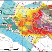
Results of the 2011 exploration program at Zymo were successful in expanding Hobbes by 180 metres in length and defining its northern limit. The zone remains open in all other directions and at depth. Hobbes remains the priority target for future work as a near-surface copper-gold deposit is outlined. Other targets on the large property continue to advance including new areas discovered at FM. Successful drilling at FM points to a large high-level porphyry system demonstrated by anhydrite bearing diorite intrusive and hydrothermal breccias.
At Hobbes, the focus was on step-out drilling to the north, east and west of the prior drilling and was successful in extending mineralization approximately 75 metres to the north, 100 metres to the east and 80 metres to the west. The mineralization remains open to depth and to the west, east and south. Mineralization covers an area defined by drilling of 720 metres by 350 metres with the deepest intersection extending to 300 metres.
At FM, two new areas were drill tsted that targeted magnetic high anomalies and associated gold and copper soil geochemistry. Drilling was successful in identifying two new areas of copper-gold mineralization.
At URC, drill hole ZY11-24 intercepted unaltered sediments. The large 200 metre by 1,500 metre copper and gold soil anomaly and coincident geophysical anomalies (magnetic high and IP high) at URC are unexplained and the URC target remains largely untested. A second hole collared on the target was lost in overburden.
For drill results at Hobbes, FM and URC, please see the table below:
| Hole (total depth) | From (m) | To (m) | Interval (m) | Au (g/t) | Cu (%) | Cu eq. (%)* |
|---|---|---|---|---|---|---|
| HOBBES ZONE | ||||||
| ZY11-20 (354 m) | 3.0 | 174 | 171 | 0.24 | 0.29 | 0.46 |
| incl. | 3.0 | 129 | 126 | 0.28 | 0.34 | 0.54 |
| ZY11-21 (342 m) | 3.0 | 165 | 162 | 0.15 | 0.18 | 0.29 |
| ZY11-22 (347 m) | 11.0 | 47 | 36 | 0.34 | 0.43 | 0.67 |
| and | 191.0 | 281 | 90.0 | 0.08 | 0.16 | 0.22 |
| ZY11-23 (351 m) | 6.0 | 315 | 309 | 0.13 | 0.21 | 0.30 |
| incl. | 6.0 | 201 | 195 | 0.18 | 0.29 | 0.41 |
| ZY11-26 (348 m) | 180 | 255 | 75.0 | 0.20 | 0.29 | 0.43 |
| ZY11-27 (366 m) | 33 | 156 | 123 | 0.15 | 0.21 | 0.31 |
| and | 183 | 255 | 72 | 0.11 | 0.19 | 0.27 |
| ZY11-28 (364 m) | 123 | 228 | 105 | 0.14 | 0.20 | 0.27 |
| incl. | 150 | 180 | 30 | 0.19 | 0.30 | 0.30 |
| FM ZONE | ||||||
| ZY11-18 (345 m) | 15.0 | 159 | 144 | 0.15 | 0.22 | 0.32 |
| incl. | 15.0 | 93 | 78 | 0.20 | 0.26 | 0.40 |
| ZY11-19 (356.5 m) | 3.0 | 356.5 | 353.5 | 0.08 | 0.11 | 0.16 |
| incl. | 3.0 | 98 | 95 | 0.09 | 0.13 | 0.19 |
| URC ZONE | ||||||
| ZY11-24 (345 m) | no sig. results | |||||
| ZY11-25 (n/a) | lost in overburden | |||||
*Copper equivalent calculations do not take into account metallurgical recoveries and are based on in-ground metal using metal prices of US$1,200/ounce for gold and US$2.50/pound for copper.
Work in 2012
Seven drill holes were completed for a total of 2,322 m and tested three target areas: FM, RD and Hobbes.
FM Target: Hole ZY12-29 was located in the central FM target area and was planned to test the zone to depth. Hole 29 was lost at 27 m and hole ZY12-29B replaced it and intersected 144.0 m of 0.08 g/t gold and 0.16 g/t copper. Further drilling will be required to determine the geometry of the mineralizing system in this area.
RD Target: Two drill holes were completed on this target. Hole ZY12-30 intersected two intervals of mineralization one of which returned 3.0 m, from 231.0 m, grading 0.99 g/t gold, 0.91% copper and 72.8 g/t silver. Further drilling will be required to determine the potential of this large target area.
Hobbes Target: The Hobbes Zone has been shown by previous drilling to extend over an area of 350 m by 720 m. Three holes were completed at the Hobbes Target. Drill hole ZY12-33 was placed approximately 100 m east of previous drilling and appears to have closed off the system in this direction. Hole ZY12-32 was located in the central portion of the zone but was directed to the southwest, the opposite azimuth of previous drilling, in an attempt to determine the geometry and orientation of the system. Hole 32 intersected a long interval of mineralization from 6.3 m for 293.7 m grading 0.16 g/t gold and 0.21% copper. The third hole at Hobbes, ZY12-34 was collared at the western end of the drill area at the site of hole ZY11-26 but was drilled to the southwest in the opposite direction of hole 26. Hole 34 intersected mineralization from top to bottom returning 297.0 m, from 9.0 m, grading 0.07 g/t gold and 0.12% copper. The hole ended in 0.1% to 0.2% copper and indicates that the zone appears to widening in this western direction to in excess of 500 m.
Access
Zymo is accessible by good quality logging roads and is easily serviced from the community of Smithers.

Technical Reports and Presentations
- ZYMO PROPERTY NI 43-101 - March 15, 2019 Viewpdf